The aftermath of this incident has been plagued by confusion [Sun and Neptune in Pisces] coming from Malaysian authorities, leading to considerable frustration as voiced by the Vietnam contingent who have withdrawn awaiting better guidance.
The Neptunian raft of confusion and misinformation, false leads, red herrings and erroneous sightings seems to increase by the day, rather than a sense of clarify and confirmation for all those awaiting news of the outcome of flight MH370
US sources are considering a deliberate act and the possibility of an extended flight westwards over the Indian Ocean.
"Multiple bursts of data were received indicating the plane was flying over the Indian Ocean, the senior U.S. official told CNN"
"This new information has now led to a decision to move the USS Kidd into
the Indian Ocean to begin searching that area, the official said"
"two separate communications systems on the missing aircraft were shut down separately, 14 minutes apart. The officials told ABC they believe the plane's data reporting system was shut down at 1:07 a.m. Saturday, while the transponder transmitting location and altitude was shut down at 1:21 a.m."
"This is beginning to come together to say that ...this had to have been
some sort of deliberate act," ABC aviation analyst John Nance told
CNN's Erin Burnett."
With this proposition, a hypothetical location west of Banda Aceh, Northern Sumatra gives a different though equally feasible template

Here at 2.45 am the full force of destructive Pluto is exact on the ascendant point of the horizontal axis, with Jupiter in opposition and Uranus at right angles. This scenario amplifies the act of destruction while in transit.
Mars and the lunar node are on their way moving to the chart's highest position so their value is high in terms of involvement in the event as postulated earlier.
[Since later information suggests an intact plane still flying hours later, the destructive aspects are likely to refer not to the plane itself wholly breaking up, but a set of actions which set in train the unavoidable but later destruction]
Update March 15
Officials are zoning in on a theory that the aircraft was deliberately flown in stealth mode in a direction towards the Andaman Island group
"What we can say is we are looking at sabotage, with hijack still on the cards," - Malaysian official
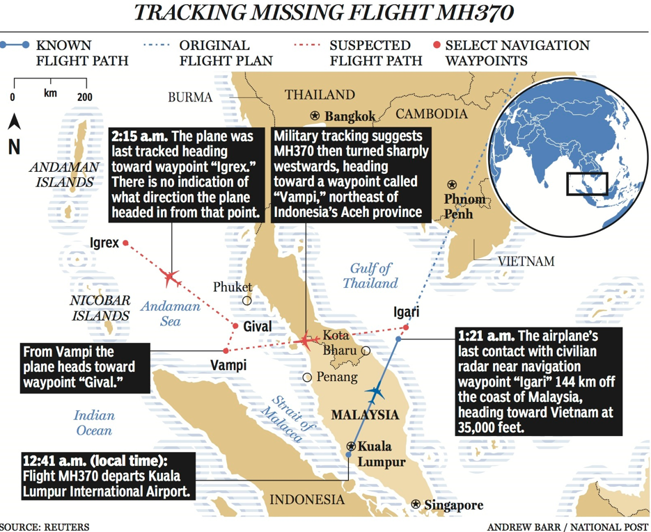
"investigators believe was Flight MH370 was following a route between navigational waypoints" - REUTERS
This Reuters graphic shows waypoints
The ping signal sent automatically from planes to satellites [even when other tracking systems seem to have been manually and intentionally deactivated] was last detected when MH370 was at cruising altitude over the Indian Ocean -
Combined with growing theories surrounding a hijack situation, the termination of the final signaling, while still at cruising altitude may indicate a catastrophic event occurred in the air - rather than the theory of a descent into the sea due to fuel running out.
On the basis of the sequence of ping signals,the plane may have flown for 5 hours after the last radar contact at 1.21am -equivalent to some 1600kms - BBC report
Significant changes in altitude and course alterations occurred after the last radar contact -NYTimes report
Investigative focus now shifts to aircraft personnel and a renewed look at passengers.
A final satellite ping of 8.10am Malay time is now established after multiple alternative versions in prior reports. This allows for the plane to reach as far as
"A northern corridor stretching approximately from the border of Kazakhstan and Turkmenistan to northern Thailand, or a southern corridor from Indonesia to the southern Indian Ocean,” -Malay PM Najib
updates March 16
Captain Zaharie Ahmad Shah, a known pro-democracy activist, has now come under scrutiny due to his expected distress, that on March 7, only hours before the flight departed, the former political leader Anwar Ibrahim, whom he ardently supported was jailed under controversial circumstances -
detailed DailyMail report
With two options now proposed by authorities in terms of a northern vs a southern aviation corridor, the north route is overland and the southern over sea.
The Malysians prefer the northern option
US sources point still to the Southern route
The astrology analysis would give much more weight to a descent into water
- Being the only sure timing for the sequence of unfolding events, the 1.19am chart [in an earlier section] shows the critical juncture at which the plane was rerouted and is therefore likely to capture all the essential ingredients of what was to come.
- Even though the plane did not suffer catastrophic disintegration from an annihilating force at that time of 1.19 a.m. a sudden event, actions or events at that time set in place the sequence that would inevitably lead to catastrophic disintegration.
- The role of a fiery or explosive element -spontaneous or planned - is still proposed as a possible precursor to later known events -although an aggressive act stemming from a "brain explosion" would also qualify -the subsequent highly irregular rerouting, the sudden climb to 45,00 ft then descent to 23,000 before resuming cruising altitude of 35,00 ft.
With the Sun, Chiron and Neptune in Pisces in the most significant location in the 1.19am chart the water theme is pronounced.
The southern direction would have been preferable to avoid radar, but the ultimate fate of a crash into the ocean may well have been the intention of the person or people in control
Captain Zaharie Ahmad Shah's extensive flying experience, his extreme interest in aviation including a home flight deck simulator, providing him with the skills, experience and even capacity to have run through any number of in-flight scenarios if he had the intention of performing an act of sabotage.
Having located his date of birth and examined the blueprint prevailing on that day, in comparison with prevailing energies on March 8 2014, there is a very high likelihood that an uncharacteristic and extreme psychological crisis erupted in the mind of the pilot,leading him to make a series of fateful decisions.
Until evidence to the contrary arises this scenario is proposed involving the Captain taking control of the plane by force, with intent to make a statement or to express his internal crisis of mind through an act of annihilation.
Charts constructed for analysis of the time-frame related to the final 8.11am Malay Time ping to satellite and the likely depletion of onboard fuel close after that time gives likelihood of a crash in the sea in the region depicted by the green spot in the graphic below
This is extremely imprecise in terms of positioning but the timeframe fits with this zone & extending towards to western edge of the Australian offshore area.
Update March 18

The pilots of MH370 Captain Zaharie Ahmad Shah & co-pilot Fariq Abdul Hamid both come under focus
on the basis of either pilot suicide/or deliberate hijacking.
The birthdate energy of both pilots shows strong connection to the 1.19 am chart - but under any circumstances that factor would be evident - since they had original control of the plane - and responsibility for the lives of over 200 people aboard.
If they were not jointly involved in sabotage, then they faced intense stress due to issues arising and Captain Zaharie, in the primary position of responsibility for the plane, shows the most stress in his energy.
[updated March 25: Various scenarios including suicide have swirled around Capt Zaharie Shah along with his regular use of a home-based flight simulator, his outrage at the jailing of politician Anwar Ibrahim and a supposed marital breakdown. A possible suicide scenario.
Full analysis by investigators has not been completed regarding the simulator and enquiries re the captain's state of mind are ongoing]
No matter what scenario prevailed, at 1.19am the pressure was on these two men to solve a big problem
New York Times reports that the westward rerouting of the plane was deliberately entered by code into the plane's computer, reinforcing theories related to a deliberate act of sabotage.
update March 19
Reuters report A sense of "deadlock" in the investigation as the task of locating the plane and the question of motive both seem to become harder.
It seems the search and investigation are still looking in the wrong places and asking the wrong questions
update March 23
Latest developments are placing great emphasis on the southern Indian Ocean as a crash site - coordinates are 90E 45S on this Chinese satellite image taken March 18
Debris of interest located by satellites is yet to be recovered by searchers for analysis. Time lags and continual drift due to sea currents mean that reverse positioning projections are being made to determine an original crash site.
If no culpability is determined for either pilot, then scenarios might be considered;
- involving either other human agents taking electronic control [this could include the cyberwar theory of a remote hacker hijack] or a spontaneous critical electronic malfunction effectively resulting in the onboard computer taking control itself after a chaotic breakdown of key functions. [Saturn square Mercury in Aquarius; Pluto square Uranus in Aries] - also read Cyberwar era
- A remote criminally-minded cyber-hacker testing out a scenario would certainly want to ditch the plane in an unrecoverable location.
- A major computer malfunction would also explain the random chaotic re-routing activity and a highly improbable flight path over a huge expanse of ocean.
- Such bizarre functioning of the plane could equally arise if a play-hacker managed to gain control.
Whether these cyber scenarios are beyond the realm of possibility is open for debate.
The momentum towards deliberate attacks of this kind looms large in our near future, if not now in 2014.
If either self-induced or remote-derived malfunction is an as yet unshielded vulnerability, effectively a weakness in the electronic brain of the aircraft, the impact on global aviation would itself be catastrophic.
update March 24
Tantalizing clues in the form of several satellite images of floating debris are yet to materialize.
An area of debris sightings is beginning to provide indications of a crash into the surrounding ocean, as determined by sea currents.
Surely these indicators will result in a focus on the seafloor north/west of the debris zone
CNN reports that "something bad happened to that plane shortly after they said good night." [1.19am]
The plane is now said to have dropped to 12,00 feet after the sharp re-routing to the west.
Aviation analyst Miles O'Brien says this is consistent with intentionally attempting to fly at a safe altitude to overcome an onboard crisis, in particular a rapid decompression risking the lives of all on board.
When decompression occurs it can be explosive with hazardous effects -and basically the same energetic signature to a bomb
Flying at much lower altitudes in an emergency provides a safe level of natural oxygen.
The nature of such a proposed catastrophic event related to explosive decompression is well within the realm of possibilities considering the prevailing energies at 1.19am March 8
Update March 25
British firm Inmarsat, who have led the charge to analyse satellite data used a more advanced mathematical analysis to pinpoint the expected final demise of MH370 -deep in the southern Indian Ocean, some 2300kms distance south west from the nearest land point of Perth Australia.
This announcement and a declaration of no survivors by the Malaysian Government comes in the wake of multiple sightings of debris in the targeted zone.
Washington Post graphics
Approximate positions given most recent information
The primary energy and prevailing dominant patterns remain the same as in earlier charts like 1.19am, but different flavours or emphases arise at different times in different locations
Using coordinates proposed as close to the crash site = debris zone 90E 45S and taking into account a 1 hour difference in the Indian Ocean timezone compared to Malaysia time 8.11 when the last satellite ping occurred, the energy here is dominated by water: Pisces as the ascendant sign with Neptune, Chiron, Sun all in Pisces - and these are in the related zone, the 12th house. Pisces is primarily the energy of water
The impact on relationships is indicated by Mars and the north lunar node conjunct in the sign of Libra and in the 8th house of endings, transformation and death
Jupiter in Cancer is loaded with potential for blessings and joy related to family matters -but when under the strain of the combined destructive forces of Pluto in opposition and Uranus at 90 degrees, joy has been morphed into extreme painful emotion.
This same slow-moving pattern remains in effect through March and April 2014 and is presently also reflected in the massive landslide disaster in Oso, Seattle US, occurring on the morning of Saturday March 22, local time, engulfing homes and possibly over 100 victims, devastating families and lifestyles.
Water, in the form of extreme rainfall is said to have precipitated the landslide.
A massive debris field has been located by Thai satellite "Thaichote" on March 24, covering the area of 89 longitude East and 46 latitude South -view extensive gallery
AMSA -Australian Maritime Safety Authory says:
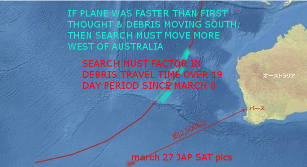
continuing analysis of radar data between the South China Sea and the Strait of Malacca before radar contact was lost... indicated that the aircraft was travelling faster than previously estimated, resulting in increased fuel usage and reducing the possible distance the aircraft travelled south into the Indian Ocean.
A large amount of debris has moved progressively south of where a US
satellite originally located debris almost two weeks ago
Then crash site is more likely to be WEST of Australia
This section of graphic below shows sites of debris sightings by satellite with a clear north to south drift versus the expected west to east due to fundamental ocean currents
Spot 9 = Thai satellite March 24 Spot 7 = French satellite March 23 Spot 5 = US satellite March 16 [8 = search areas]
A ballpark figure of 100kms per day drift means that by spot 5 16 March, the debris may have drifted up to 800kms south
Positions true west of Perth ought to be considered, particularly this red-hot zone marked

Three additional areas with sightings in the period March 16-23
MRSA = Malaysian Remote Sensing Agency
update March 28
Latest search zone just announced LOL just where my amateur calculations with a ruler, basic maths & common sense expected based on analysis of the succession of satellite sightings and the drift of debris over time.
The new search area is around 1680kms west of Perth and much further north/east than recent searches:
Update March 29
Debris has been sighted in the new search zone by several planes and will be followed up by a Chinese ship today - report
A lithium ion battery induced fire cannot be discounted: the plane's cargo manifest contained 440 pounds weight of these batteries [the rechargeable type used in phones and laptops]
... lithium ion batteries were the main suspect in the crash of a UPS Boeing 747 in Dubai in 2010, killing both pilots as they tried to make an emergency landing. Investigators in the United Arab Emirates studied the cargo records and found that shipments of lithium ion batteries that should have been declared hazardous cargo were not. The reinforced cargo liner was no match for the fire that quickly destroyed the aircraft's control systems and filled the cockpit with smoke, incapacitating the pilots -CNN report
update April 6
As the hours countdown to the point of silence, Chinese authorities announce new potential evidence of MH370 on the seafloor -
The new search zones planned for April 6 are some 660 miles off the coast of Australia, the nearest town being Exmouth.
Chinese searchers appear to be taking their own initiative to solve the mystery.
Latitude 25S, longitude 101 E is quoted as a potential location for the signals sent at 37.5 kHz - the exact frequency used by cockpit voice recorders and flight data recorders
update April 7
The closest landpoint reference is the Learmonth RAF base near Exmouth township. This locality can be used for any astro-analysis chart reference if the wreck is located in the region suggested above.
With so many false leads & reversals of information plaguing this incident, full analysis cannot proceed until firm evidence is recovered.
Update April 9
A 100sq mile zone now becomes the focus as searchers narrow down the likely crash site.
An array related to ping signals is expected to be the most credible evidence yet of the underwater location of MH370
Report
Update April 17
Australian authorities report that acoustic analysis " has allowed the definition of a reduced and more focused underwater search area. This represents the best lead we have in relation to missing flight MH370 and where the current underwater search efforts are being pursued to their completion so we can either confirm or discount the area as the final resting place of MH370."
update April 25
Underwater searching has failed to locate any evidence of MH370 - leaving the recovery mission at a sustained state of deadlock -Reuters report
update June 4 2014
Weeks have past with no new developments.
Progress remains excruciatingly slow, with even the undersea ping signals now in doubt.
update June 24 2014
News report has Captain Zaharie again under focus now that retrieved data erased from his simulator indicates Indian Ocean flightpaths
update June 28 2014
A new search area and further theories attention shifts to another location off the west coast of Australia
update August 2017
August 2017 new search zone based on re-analysis
===================================================================================
Further material of relevance:
Air France AF447 May 2009
Detailed analysis of the astro-energies in play when both events occurred shows distinct differences.
Wikipedia entry on AF447 states:
The final report, released at a news conference on 5 July 2012, stated that the aircraft crashed after temporary inconsistencies between the airspeed measurements—likely due to the aircraft's pitot tubes being obstructed by ice crystals—caused the autopilot to disconnect, after which the crew reacted incorrectly and ultimately led the aircraft to an aerodynamic stall from which they did not recover
It took 5 days for the first bits of wreckage from AF447 to be located - with the bulk of the recovery process extending a further 2 years -via Stuff
May 31 2009: the plane left Rio at 19.29 local time [22.29 UT]
May 31 2009: the plane hit water at 2.14 UT = 23.14 local time.
The following charts show comparative times using Natal, Brazil land location, representative of the regional energy conditions:
The charts look at 11pm, 11.02pm, 11.14 pm.
The key positions to view initially are the trio grouped at the left horizon:
Chiron, Neptune, Jupiter all in Aquarius 26.14 to 26.42
The horizontal axis is ascending at 26.02 Aquarius.
Uranus is at 26 Pisces an exact semi-sextile angle to the above positions.
Uranus is the planetary energy associated with Aquarius & those aviation as well as all things electronic.
Aquarius is the energy associated with all forms of aviation
Jupiter is the energy of travel over large distances
Neptune is the energy of chaos and confusion
Chiron is associated with wounding or damaging experiences
Uranus in Pisces in tight connection adds in confusing electronic factors
The location of these factors all in extreme conjunction at the rising point of the chart is majorly significant in confirming the overwhelming confusion that affected the pilots.
Between 11.00 and11.14 this group rises up over the ascendant point, but remain just 3 degrees from that position.
The karma/destiny signifier is the north lunar node at 1 Aquarius
It sits at the start of the 12th House of the wheel
It's position is also critical:
By 11.14pm the lunar node at 1.35 Aquarius is virtually exact at the midpoint of Pluto -2.32 Capricorn - and the AC -ascendant point which had then reached 29.38 in Aquarius
The exact midpoint at the supposed time of submersion was 1.05 Aquarius
Scan along from the Pluto gylph top left to 1.05 AQU which is the midpoint to the ASC.
MIDPOINTS analysis often reveals the hidden energies at work
Witte's theory of cosmobiology is indispensable in showing how combined energies are potentized at the middle position where they meet
This midpoint grid for 11:00 pm May 31 2009 has relevant examples in the loss of AF447
Other pairings meet = have midpoints - in the range 26-29 Aquarius:
Mercury-MC, Venus-Pluto, Uranus-North Node - adding power to the grouping already identified.
The north node at 1 Aquarius is in range of positions from late Capricorn to early Aquarius which will reinforce the significance of the destiny issue
Pairings in late Aries, Cancer activate late Capricorn as well by angular opposition or 90 degree square so these are included:
Sun-Saturn, Venus-Mars, Jupiter-Pluto, Uranus-MC, Neptune-Pluto, Pluto-Chiron
Another interesting factor:
Uranus the aviation planet was in the water sign Pisces associated with the planet Neptune
Neptune the water planet was in the aviation sign Aquarius which is associated with the planet Uranus
This is termed mutual reception
Both planets were at 26 degrees reinforcing the fact that the two forces were contaminating each other with incompatible energies - mutually cancelling out their essential functions.
Four key ingredients signify a major event as seen in the AF447 disaster:
- Tightly grouped and multiple linked planets occupying or meeting at particular repeated positions eg several situated at 26 degrees or pairs with midpoint at 26 degrees
- The lunar nodes [an axis identified by the north node position] have multiple factors in connection
- Significant involvement of outer planets -Jupiter, Saturn, Uranus, Neptune, Pluto
- Angular connections are the primary signifier, ahead of location and zodiac signs, though positions on or close to the horizontal and vertical axes have major relevance to their potency
#################################################################################
|
Crash analyst's assessment:
|
 Airbus crash kills 150 in French Alps. On March 24 just four days from the eclipse exactitude, Germanwings 4U9525 appears to have hit a mountain range near Digne. Due to the involvement of mega-forces, aviation disasters are high risk in this period -the resonant pattern of Pluto square Uranus is seeking earthing points.